- Home
- Forum
- Xamarin.Forms
- centre map
centre map
I have begun experimenting with sfMap
I simply want to use OSM worldmap but zoomed to a particular location.
I can work out the zoom level required but I cant figure out how to (programmatically) pan to the required location.
I note a previous post over a year and a half ago said there was no functionality to centre a map
Is there now any way to achieve what I am trying to do ?
tia
JM
SIGN IN To post a reply.
3 Replies
SS
Sheik Syed Abthaheer M
Syncfusion Team
November 5, 2018 10:41 AM UTC
Hi John,
Thanks for contacting Syncfusion Support.
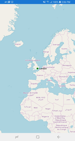
We can achieve your requirement of zooming the location by specifying the desired latitude and longitude in the GeoCoordinates property of imagery layer as like the below code snippet,
| <maps:SfMaps ZoomLevel="3"> <maps:SfMaps.Layers> <maps:ImageryLayer x:Name="layer" GeoCoordinates="51.509, "-0.1180"> <maps:ImageryLayer.Markers> <maps:MapMarker Label="London" Latitude="51.509" Longitude= "-0.1180"/> </maps:ImageryLayer.Markers> </maps:ImageryLayer> </maps:SfMaps.Layers> </maps:SfMaps> |
Please find the output screen shot
Please find the demo sample from below location
Sample: MapsPanning
Regards,
Devi
JM
john murray
November 5, 2018 12:31 PM UTC
many thanks
I know you've all pretty much moved exclusively to xaml but it would help to see the c# equivalent
MP
Michael Prabhu M
Syncfusion Team
November 7, 2018 08:45 AM UTC
Hi John,
Based on your query, we have prepared the sample in code behind. Please download the sample from the below link,
Code Snippet:
C#:
| SfMaps maps = new SfMaps(); maps.ZoomLevel = 3; ImageryLayer imageryLayer = new ImageryLayer(); imageryLayer.GeoCoordinates = new Point(51.509, -0.1180); MapMarker marker = new MapMarker(); marker.Label = "London"; marker.Latitude = "51.509"; marker.Longitude = "-0.1180"; imageryLayer.Markers.Add(marker); maps.Layers.Add(imageryLayer); |
Sample:
Regards,
Michael
SIGN IN To post a reply.
- 3 Replies
- 3 Participants
-
JM john murray
- Nov 3, 2018 03:09 PM UTC
- Nov 7, 2018 08:45 AM UTC
